


Smart Cities need 4D Spatial
Bruce Thompson, Executive Director, NSW Department of Finance, Services and Innovation

Bruce Thompson, Executive Director, NSW Department of Finance, Services and Innovation
Smart cities can only achieve limited benefits realization without a comprehensive 4D spatial framework. Why? Because a smart city is a complex network of hundreds of thousands, if not millions or billions, of smart objects. Just as these smart objects need to connect, relate and integrate into complex supply chains and networks to operate, they also need to position themselves precisely in space and in relationship to each other to be truly effective. Digital engineering, asset management, and building information management systems will all require 4D spatial. CIOs and ICT professionals need to understand and make provision for the spatial dimensions of objects, systems and architectures to ensure their forward path is not constrained. At the same time, the spatial sector urgently needs to lift its game to provide a full blown 3D model of the physical environment with full temporal capabilities – a comprehensive 4D spatial framework.
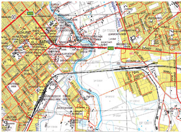
What is a comprehensive 4D spatial framework? Australian States and Territories and the Australian Government have, like many other jurisdictions, developed a standard approach, in our case described as the Foundation Spatial Data Framework (FSDF). It consists of ten broad data themes: land parcel and property, address, administrative boundaries, transport, hydrography, elevation and depth, land cover and land use, placenames and positioning. However, the FSDF as it stands is no longer fit for purpose –designed for printing 2D maps, not for generating a 3D model. A river is not a blue line on a topographic map, it needs to be a full 4D entity with flow direction and volume, water rights, flooding characteristics and the laws of physics applied to it – water can’t flow up hill in the real world, so neither can it in the digital representation. The graphic below shows the difference between 2D and 3D spatial data.
Then there’s the fourth dimension—time. Being able to view critical time stamps – approvals, milestones – will be necessary, as will the ability to show future projections and forecasts.
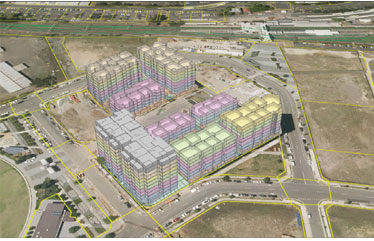
Most of you will be familiar with the digital twin, particularly in respect of the digital twin organization. A 4D FSDF is a Digital Twin for the physical world (Singapore is well advanced in this). Critically, it needs to be comprehensive and accurate, as hundreds of thousands of asset owners will want to place their assets into the digital twin, to allow them to interact with each other. A building will want to understand the location and attributes of utilities and services. Infrastructure, particularly transport infrastructure, will need to connect to form networks. A coffee shop will want to understand pedestrian traffic flows. Temporality is also critical, as buildings and assets will be inserted at design stage, and modelled through their life—approval, construction, operation, demolition/ decommissioning. Designers and operators will use the digital twin as a digital work bench.
Not only will it allow their asset to be placed in context, but data and content from surrounding assets – whether partners, stakeholders or competitors – will be available to inform design and operation.
Getting from 2D to 4D will be difficult, as will the change in practices and behaviours required to fully achieve the potential of a digital twin for the physical world, but the benefits are significant. No part of a smart city can achieve its full potential unless it is accurately located in relationship to its surroundings.
Key messages?
• Planning
No part of a smart city can achieve its full potential unless it is accurately located in relationship to its surroundings
Plan assets, organizations and objects as part of a digital ecosystem that faithfully represents the real physical world. Allow your asset, organization or object to harvest data from its surrounds, as well as publish information about itself. Technology is soon going to be capable of generating and supporting a detailed and current 4D model of the physical world and our built environment. People, process and systems will be placed into this model for planning, analysis, scenario testing and for operations.
• Positioning
Accurate positioning is critical – 5cm to 20cm is likely to be the range, with real time management of continental drift and other movements of the earth’s surface. Australia is moving north-east at 7.5cms a year. Park your autonomous vehicle using two year old positioning data and you’re likely to scrape a post.
• Privacy
Privacy in the digital twin will be essential, and will need to faithfully reflect real world privacy requirements. If you can see it walking down the street in the real world, you’ll see it in the Digital Twin. If your house or office is locked in the real world, it’ll be locked in the digital twin (but you’ll have the ability to grant one-time or limited access to others – perhaps a tradie quoting to renovate your kitchen, or the Fire Brigade).
• Access and Licensing
In conjunction with privacy, think about data access and licensing. Governments will be looking at ‘whole-of-economy’ licensing for the digital twin imagery and model – because the whole point is for everyone to be able to use it to collaborate. Private companies and individuals may also achieve commercial or other benefits by sharing some or all of their data with stakeholders, partners, and potentially even competitors.
Location and positioning are fundamental attributes of any smart object, smart network or smart city. Getting the 4D spatial framework right will be key to the success of our smart cities.

Weekly Brief
Read Also

